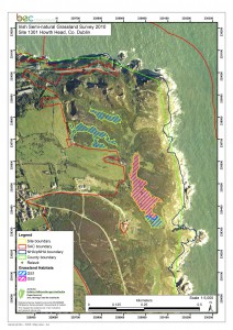
All BEC Consultants staff members are highly experienced in using Geographical Information Systems (GIS) and use GIS at both planning, data analysis and data presentation stages of projects. As a company standard ESRI ArcGIS 9.0 and 10.0 are used; we are also experienced in converting outputs for use with other platforms such as MapInfo and QGIS. We are experienced in aerial photographic interpretation and the identification of habitats using GIS; these form a core component of our skillset.
We have used GIS to produce high quality maps for use with reports for projects such as the Irish Semi-natural Grasslands Survey, the National Survey of Upland Habitats and the Killarney National Park Habitat Map. In addition to the production of site specific habitat maps, we have utilised GIS to compile national distribution maps for a range of Annex I habitats including Blanket bog, Calcareous grassland and Wet woodland through the National Conservation Assessments project. At a regional scale, we created a GIS containing all existing habitat information for County Waterford for the Waterford Mammals GIS project. These data were then analysed to investigate the permeability of the landscape in Co. Waterford for mammals.
Through these projects, we have gained extensive experience in data capture, spatial database creation and management, dataset cleaning and verification, such as dealing with overlaps and inaccuracies, and producing clear user friendly maps and topologically correct GIS datasets. Our experience in utilising GIS for a range of environmental projects, combined with our expertise with habitats throughout Ireland make BEC Consultants ideally suited to carrying out all habitat mapping and ecological GIS projects.
